- Language
- 日本語
- English
- Português
- 中文
- Tiếng Việt


Think about [disasters] with your family and local area habitually.
"Just in case" be ready.
Flood and Sediment Hazard Map (Digital version) was created based on the Flood and Sediment Hazard Map (preservation version) made in March 2020. You can see at a glance the depth and range of the water that is assumed when Takashi river, Shinpon river, Ashimori river, Suna river, Mae river flooded. In addition, landslide may occur during heavy rain, the evacuation location of each district is posted together.
This map shows the dangerous places at the time of disaster. It is made to help every citizen to think about early voluntary evacaution with their families and local areas.
When disaster might occur, be careful about the weather information or city information and keep in mind to evacuate early.
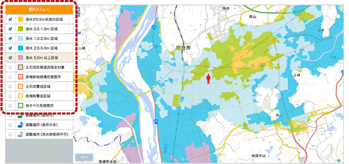
Display of dangerous zone, assumed flooded district
If you click the button on the left side, it will display the area of the assumed flooded and landslide district.
The check box is not only for ON/OFF button, you can also click the characters.
- The explanation of Display
- Selection point (The initial display is the center point of the district).
- Flooding areas less than 0.5m.
- Flooding areas from 0.5 to 1.0m
- Flooding areas from 1.0 to 2.0m
- Flooding areas from 2.0 to 5.0m
- Flooding areas more than 5.0m
- Special Warning of Area with Dangers of Land slides(Debris flow)
- Special Warning of Area with Dangers of Land slides(Steep slope)
- Warning of Area with Dangers of Land slides(Debris flow)
- Warning of Area with Dangers of Land slides(Steep slope)
- Warning of Area with Dangers of Land slides(Landslide)
Display of Evacuation sites
If you click the button on the left side, you can view the evacuation site on the map.
If you will click the evacuation site mark that is displayed on the map, the details of the evacuation site will come out at the top of the screen. To hide the screen, click the [close button).
Evacuation site has been divided into 3 types (available) (conditional) (unavailable in time of flood). This is because it has also been designated as a shelter for earthquake and other disasters. In time of flood it is specially indicated differently.
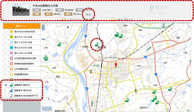
- Explanation of Display
- Evacuation site (Available)
- Evacuation site (Conditional) *Individual conditions (remarks) will be displayed in the part of detailed information on the screen
- Evacuation site (Unavailable in time of flood)
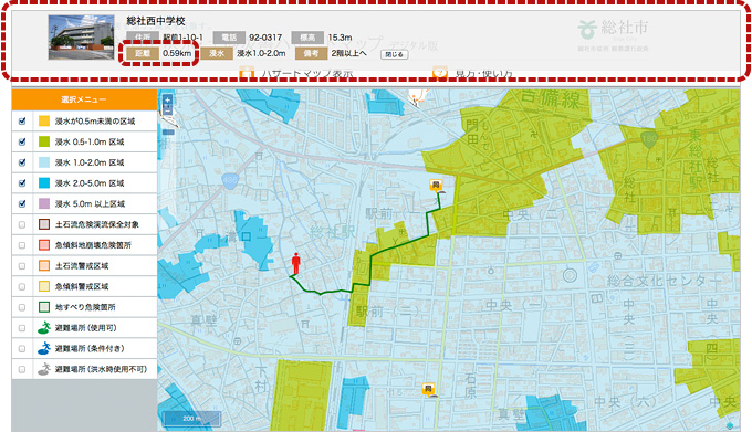
Nearest evacuation site display
On the map when you double -click a mouse to the location you choose, the humanoid mark moves. From it the only nearest 5 evacuation sites will be displayed.
At this point 5 evacuation locations are displayed in 3 different marks.
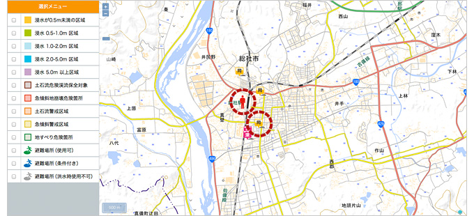
- Explanation of Display
- The 3 types of marks are, if you click the humanoid mark connecting straight to the shelter, the flooding situation around will be displayed separately.
(It is not the description of the "route" in the next section, in case you are connected to the straight line, ignore the topographical information) - If you do not pass through the flooded area
- Same as humanoid mark, or, if you pass through a shallow area
- If you pass through an area deeper than humanoid mark
The nearest evacuation site and distance in details, route display
In (3) If you click the displayed shelter mark, from the humanoid mark the distance is automatically calculated and showed at the top of the map.
Also, the distance to the evacuation site is displayed on the detailed screen 「distance」
Determine the best thing of yourself through your experience and knowledge.
- Explanation of Display
- The distance from the point that you set (humanoid mark) to the evacuation site
Others, You can resize or scale the part of the map and be able to move the displayed range.
Let's take a look not only your surroundings, schools and places where your children usually go, take a look at the focus various places on the hazard map.